History of the Percy Portage
By Michael Levenston Trent University, 1973
Part of the 180-page Percy Portage report.
By Ferne Crystal, Gordon Holyer, Beverly Hood, Robin Hood, Michael
Levenston and Borge Lind-Petersen
Trent University Press 1973
Also see the Story of the Percy Portage
In searching for a lost portage, it is the early maps which are our primary source. The Indians have left us no descriptive account of their Trent Valley. They knew its water paths and land highways for thousands of years before European intrusion and needed no permanent record. But the native people guided the earliest white explorers and mapmakers through the territory and left some of their wisdom with them. What few clues remain identifying the ancient carrying place through Percy Township must be taken from information set down by these first draughts men on the Trent (the river was named Sagetewedgewam by the Indians).
The oldest known marking of the Percy Portage can be found on the 1790 Holland-Collins map(1) of the District of Nassau (central Ontario), which was prepared from different surveys made in the previous five years.(2) Written upon one of the three surviving copies of this map is the first description of the path,
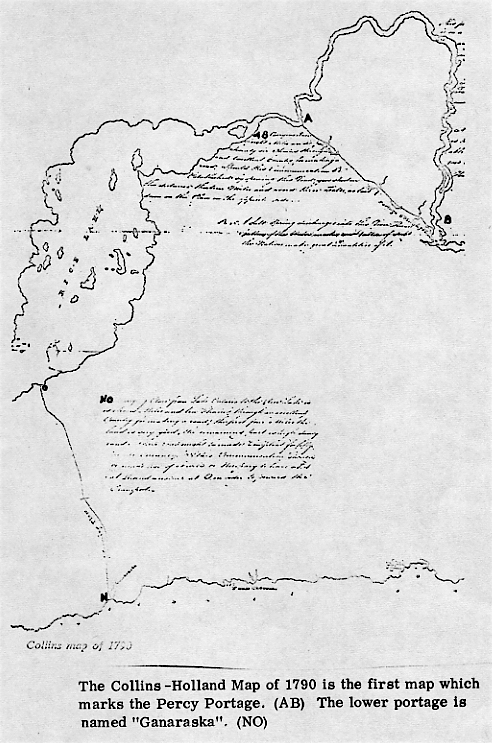
AB Carrying Place of eight miles and Seventy six Chains through an Excellent Country for making a road, Should this Communication be established by opening this Road, you shorten the distance thirteen Miles and avoid three Falls as laid down on the Plan on the opposite side
Very little is to be gained from this lone description. So it is necessary that we give a brief account of the events that led up to Collin's journey over the Percy Portage in order that the description may have its full historical significance.
Between the year of their victory (1763) and the Treaty of Paris (1783), the British made little effort to settle or understand the lands in Upper Canada. During those twenty years the unsettled condition of the Americans, the French, and the Indians kept the new government occupied. It was the influx of Loyalist and Six Nation allies, which finally necessitated the discovery of new, good land for settlement.
Frederick Haldimand, the Governor-General of Quebec sent out exploring parties up the St. Laurence as far as Cataraqui, the old French fort which is now Kingston. His Surveyor-General, Major Holland who made the observations at Cataraqui in June 1783, directed Captain La Force, Mr. Cotte, and Mr. Peachy to survey the north shore of Lake Ontario all the way to Niagara. By October of 1783, Captain Crawford had purchased from the Mississagues that portion of the north shore of the St. Lawrence River and Bay of Quinte, from the Gananoque River to the Trent River, enough to allow John Collins to lay out the first township in Ontario, Kingston.
Collins continued plotting townships in that month. Ernesttown, Fredericksburgh, and Adolphustown were completed, leading him to the east side of the Bay of Quinte. General settlement work continued in this area for the next few years.
Sometime in either February or March of 1785, the new Lieutenant Governor of Quebec, Henry Hamilton, learned of the Trent waterways system. In a letter to the Colonial Office in London, Hamilton tells his superior, Lord Sidney, of his knowledge of a new communication route to Lake Huron and his impressions of its usefulness.
Quebec, March 10, 1785 My Lord, A project having been layd before me for establishing a carrying place on the communication between Cataraquoui and Lake Huron, I have taken the steps I judged necessary for gaining a competent knowledge of the various circumstances to be attended to in such an undertaking in order to lay them respectfully before your Lordship. The advantage to the commerce of this Country (as the matter has been stated to me) are many, such as abridging the time, provisions and number of men, hitherto necessarily employed in the Transport, by the way of the Grand River called by the French la Riviere des Outaouais, upon which communication there are thirty six portages. Whatever merit there may be in suggesting such a plan, I cannot claim any. Monsieur de Rocheblave is the person who mentioned it to me, and if it should be approved by Your Lordship, I humbly solicit in his name, a grant of the carrying place for him, and such persons as he may be desirous of being associated with him, in the prosecution of this plan. Exclusive of the benefit to result from this project to the trade of this Province, I beg leave to mention to Your Lordship, the advantage of having a communication which will be secure from the jealous interference of our neighbours; the assurance it will give to the Indians, of being supplied at a cheaper rate, than they can be by the Americans; the means of keeping open an intercourse with any posts it may be thought proper to establish in the Upper Country. I shall as the weather permits, order a survey to be taken by the Deputy Surveyor of the Province, to be transmitted to Your Lordship with all possible speed... (3)
The letter probably refers to the Toronto route. It is more than likely that at this same time Monsieur de Rocheblave informed Hamilton during their discussions of an alternative Trent route. In the letter quoted above, the analysis that is made of the Toronto communication route is interchangeable with any analysis that could have been made of the Trent in 1785.
Hamilton is not too interested in the benefits that will result for the fur traders who may use this less arduous route. He sees it rather as a means of defending the country and its inhabitants from the Americans. The trade will be kept from the American traders; the Indian's welfare will be protected from American high prices; and any future frontier posts will have a safe supply route home through the interior, rather than through Lake Erie.
On that same day, March 10, Hamilton also sent a letter to Benjamin Frobisher(4) questioning him about his understanding of any communication' from Lake Ontario to Lake Huron. Hamilton thought it wise to ask Benjamin since Benjamin and his brother Joseph were known to the Quebec government as intelligent fur traders. They knew the West and the problems that different travel routes posed. In October of 1784(5) they had written a detailed explanation to General Haldimand of the 'hardly known' fur trade that had gone on for years to the west of Montreal beyond the Grand Portage. Through the letter, they hoped to obtain for their company favour and protection as well as an exclusive right to the trade of the North-West.
Before they sent their answer to the Lieutenant Governor, Hamilton discussed the L. Huron communication further with Lord Sidney. In his letter Hamilton hopes that British merchants will begin to form commercial agreements with the "avaricious" Americans as these former colonists have a "predilection" for British manufacturing. And while these particular economic interests are being developed, he sees a healthy "peltry trade engrossing" Canadian merchants and Hudson's Bay traders.
April 7th, 1785 ...With regard to this last object, I have reason to think there may be very great improvements take place and in that view have thought it my duty to submit to Your Lordship's consideration a project for a communication from Montreal to Lake Huron mentioned in my last letter. A Plan of part of that communication accompanies this letter and as I had the honor to mention to Your Lordship, I shall order the survey of the remainder to be proceeded upon this Spring, and have hopes of getting satisfactory accounts of the natural state of the Country and of what obstacles may stand in the way of the prosecution of this design...(6)
Hamilton received his answer from Benjamin Frobisher on May 2, 1785.
I have seen several persons who have gone from hence to Lake Huron by the carrying place of Toronto, but have only met with one who set out from the Bay of Kentie (by the Trent River) and that so far back as the year 1761 and knowledge he seems to have of the Country he travelled thro' I consider as very imperfect. I have however laid it down, in the enclosed Sketch, more to shew that there is such a Road, than any opinion I have of its being Correct - I am told the Lands from the Bay of Kentie to Lake la Clie (Lake Simcoe) abound with good Wood and are generally fit for Cultivation. There are several Villages of the Mississagues on different parts of that Road, who raise Indian Corn and other grain and whose friendship it will be necessary to Cultivate. If upon survey it should be found practicable, but if I may rely on information, there is very little probability of establishing in that quarter a Communication for Boats or Large Canoes, on account of the Water being generally very shallow between the different Lakes, except in the Spring, and even then, it is described to me, as being insufficient for large Canoes, not to mention the Carrying Places, which are Six or Seven in Number to reach Lake la Clie, and I am told two of them are near three leagues in length; I am however informed that to the distance of the Rice or the Folle avoine Lake from the Bay of Kentie, there is plenty of Water for Boats of any Burthen - From all these circumstances as related to me, I judge a Communication that may, without paying any regard to the carrying Places, to be from the want of Water totally impracticable, however as I believe there is no Man in the Country capable of giving any certain information about it, I think a Project that holds out so many advantages to the Province at large ought not to be relinquished, until it is found upon Survey, to be represented really impracticable...(7)
Frobisher was looking for a good inland trade route to Lake Huron. In the complete letter he dismisses the Ottawa River route because of its "eminently dangerous" nature. He finally urges that the Toronto Carrying Place be established instead of the 'Bay of Kentie to Lake la Clie way.
But for the historian, his report asks more questions than it answers. Why had he so little information about the Trent system? He must have known every important trader and many Voyageurs. However, he only spoke to one man who gave him a very poor account of the journey at that. His informer told him that the upper lakes were too shallow for loaded boats and spoke of the Lower Trent as the easily traversed portion.
Whatever beliefs this experienced and reputable Frobisher may have had, he cannot dismiss the Trent Valley as a trade path, for there are four valuable remarks made in 1815 and 1816 which show that fur traders of an earlier time used it.
In Reuben Sherwood's memoir of his voyage up the Trent (1815, see appendix), the author makes two references to the feats of former travelers.
At Bobcaygeon,
The first stream is the one used for canoes to
pass up and down: but the larger or Northern stream is that which the
fur traders formerly used to run their boats up and down.
At Fenelon Falls,
The falls are a perpendicular pitch of 17 feet and there may be a
fall of 3 feet more in the distance of 300 paces up to Cameron's Lake.
The fur traders used to take boats past this place on rollers of wood
without the help of horses or oxen for the small distance of 50 yards.
On one Owen map of 1816, the upper rapids at Bobcaygeon had this marking, "The Great Rapids formerly navigated by Traders." And finally at Otonibee Landing (near Peterborough) at the foot of the Chemong Lake portage the map has indicated
that The whole distance hence, thro' the Tripe Lake (probably Story and Clear Lakes) to the Head of this Portage (Chemong) said to be 50 or 60 miles: it is frequently navigated by the Traders Batteaux tho' a strong rapid all the way.
Why so little was known of the Trent waterway cannot be determined until further documentation is unearthed, which can tell us in what years fur traders made use of this system. It is possible that French traders used the route but that the British conquest in the early 1760's brought a halt to their commerce. And it is also possible that the route may have come back into use as a result of the interest shown it in 1785.
Perhaps Henry Hamilton wasn't sure of Frobisher's facts either for on May 22, 1785, John Collins was directed to explore the Trent.
Quebec, May 22, 1785 ... you will proceed upwards to take a survey of the communication between the Bay of Quinte, and Lake Huron by Lake La Clie (by the Trent). You will particularly note the depth of water at every necessary place and mark the soundings on your plan or chart. The parts navigable for the different sorts of crafts - the nature of the soil, and its produce particularly timber. The Indian tribes, on the communication, their numbers, disposition, etc. What tract of land it may be necessary to purchase, and at what rate. Calculate the time and expense of rendering the different portages, etc., practicable, consider and weigh well the disadvantages as well as favorable points. The time which the transport of goods would require if the roads were in good condition. Consult the merchants at Montreal, upon the idea of erecting stores at the different convenient places, and if you find they are desirous of encouraging the project, write me immediately. Your prudence will suggest the necessary measures. I wish you all health and good weather, and am, Sir, Your most obedient and most humble Servant, (Signed), Henry Hamilton. John Collins, Esquire, Deputy Surveyor General. (8)
In this first order, the thrust indicates an interest in a practicable water and land communication for the fur trade that would include fertile areas for settlement and timber resources for harvest. A week later new instructions change the tone somewhat.
Quebec, 28 May, 1785. Additional Instructions to John Collins, Esquire, respecting the surveys in the upper Country: You will take especial notice in your report of the stations which may be most advantageous for the erecting forts, redoubts, or batteries, having in view, first the protection of the shipping or small craft, secondly the advantages of giving shelter and security in case of an attack from a regular force, or in the event of an Indian War. The nature of the soil, the distance of commanding grounds, the means of procuring water, and of keeping communication by land and water are to be considered.(9)
Here Indian and American threats necessitate the discovery of a route that is also defensible. Hamilton wants an alternative waterway on the Trent in case American warships take hold of Lake Ontario or Indians threaten to attack the Bay of Quinte homesteads.
Benjamin Frobisher was obviously very pleased with Collin's work for his enthusiasm is unbridled in his December 15th, 1785, letter to Henry Hamilton.
Suffer me to remark that the province must reap the most lasting advantages from it, being convinced that a communication of transport between them, (the lakes) will not only lead to the Extension of Our Agriculture and Commerce, but also to the Establishment of a Formidable Frontier against our American neighbours ... (10)
When John Collins (11) finally mapped out the communication in 1785, his walk across Percy predated the first survey of the township by ten years and the first settlement by thirteen years.
His almost straight-line course crosses three streams and possibly a fourth that may be Percy Creek. Collins mentions the eligibility of the overland trail since he has also gone around the long way, up the river and has met falls and portages at every step.(12)
To the government, Collins had made the more important discovery in this vicinity near the Percy Boom entrance to the portage. "A Salt Spring discharges into this River, Three Gallons of the water makes one Gallon of Salt, the Natives make great quantities of it ..." (13) News of this spring even reached Governor Simcoe and he states in a letter of December 7th, 1791, to Henry Dundas, that this has given him "a singular pleasure".
A salt spring would be considered an inducement to settlers. They could raise pigs and than salt the pork for sale to the troops. Interest in this particular site demanded further exploration and in late June, 1792, William Chewitt, a Deputy Surveyor, made his way to the actual spring.
... 29th June - at 6 A.M. began blazing the route to the Salt Spring, being about four miles and a half, the first part for about a mile is swampy; arrived at the spring about 9 A.M. and upon examination found it to be a perfect mud hole about two and a half feet in diameter, with no run from it, containing about 12 gallons and strongly impregnated with sulphur to the smell and taste nearly like a solution of gunpowder, which induced me at first to believe it had been some imposition of the Indians, but upon baling out the water and clearing it of mud, we found a clay and gravely bottom, the water rose from 10 A.M. to 10 A.M. next morning, the same height, very clear and about the same quality. (14)…
The spring never amounted to very much but its fame made it a landmark which found its way onto Smyth's 1800 map of Upper Canada. The portage is not placed on this map but is replaced by a "Salt Springs" title, which sprawls over part of Percy and Seymour. Because of this, the draughtsman has been forced to squeeze the two township names away from where they ought to be. For some reason he has also included a non-existent "Dives" township above "Hamilton". Everything above the Trent River was still Indian land and is labeled "Immense Forests, Hunting Country".
The "Salt Spring" landmark in Percy is more important to Smyth on his 1800 map than the Percy Portage.
By 1800 there weren't more than ten to fifteen families settled in Percy. William Hambly had mapped the township in 1795 and in July of 1796, Aaron Greely (16) made comprehensive field notes by concession and lot. He listed whether soil was poor or good, what types of timber existed, how hilly or level a lot was and whether there were brooks, rivers, mill-seats or swamps in a specific area. Neither man makes any note of the portage.
Not long after these first surveys were completed, Asa Danforth and Aaron Greely became agents for the township. Their duty was simply to bring in the first settlers to Percy and start them farming. The list of settlers, which they produced for the government in 1797, included twenty-six names.
June 17, 1797 Ezra Wildman 1873, Thomas Gastin 17/1, Rolluff Whitney 19/3, Amasa Brunson 24/2, Barnabas Brunson 23/3, Elias Turner 20/1, John Dicky 24/3, Daniel Silver 9/4, Elihu Lincoln 12/3, Resolved Cleaveland 18/1, Solomon Woodworth 14/4, Abner Silver 14/3, Samuel Pitts 24/1, John Richardson 17/3, Samuel Danforth 22/1, Benjamin Richardson 18/3, John Dunn 15/1, Joseph Richardson 19/3, Gardner Cleaveland 18/1, Roger Merril 24/3, Stephen Ticknon 12/3, John Devine 16/3.
When two years later a Deputy-Surveyor named Augustus Jones provided the government with a list of the settlers whom he found actually living in the township, the number was nowhere near twenty-six. Less than ten people were working their land.
Thomas Gastin - Lot 17, Con. 1, about 3 acres partly cleared, said to be
gone to the States to Bring in his family.
Gardner Cleavland - Lot 18,
Con 1, no improvements, said that his sickness prevented him improving.
- also said that he is gone to the States to Bring in his family and
settle.
Elias Turner - Lot 20, Con 1, about 2 acres partly cleared, said
to be in the States
Justus Spalding - Lot l4, Con. 2, about 10 acres
clear.
Resolved Cleaveland - Lot 19, Con.2, about 5 acres cleared,
occupied by a tenant.
Barnabas Brunson - Lot 24, Con. 2, about 10 acres
cleared.
Abner Silver - Lot l4, Con. 3, about 3 acres cleared, not
settled.
Jacob Dingman - Lot 12, Con. 3, about 4 acres cleared.
Roger
Merril - Lot 24, Con 3, about 4 acres cleared.
Ezra Woodworth - Lot 14,
Con 4, a very trifling improvement, gone to the States sometime since.
Richard Sharp - Lot 12, Con 4, a small house and a trifling clearing.
Eliha Lincoln - Lot 12, Con 5, about 6 acres cleared.
Rufus Well - Lot
13, Can 4, about 2 acres clear, living in Cramahe.
Amos Brunson - Lot
23, Con 4; about three acres clear.
Signed A. Jones D.P.S.
Since Jones' report showed that the original agents had cheated the government, it was damning evidence against them. The first and possibly greatest scandal of Percy's history became public in July of 1799. His Honour Peter Russell, presiding over the Council Chamber at York, spoke against the wrong-doors in angry tones and dealt severely with their ways, using cleansing corrective measures.
The Board took into consideration the Reports made by Mr. Jones on the state of the townships of...Percy, together with the Counter Reports of Mr. Rogers, Mr. Greely, - In pursuing these Reports and counter reports, the Board meets with hardly anything but additional proofs of the fraud, duplicity and unprincipled selfishness of the original Nominees of those Townships, who never took to settle them with new inhabitants, appear to have brought into them persons already settled in the province and in many instances have only borrowed Their names - The Board therefore earnestly recommends that the order of the president and Council, by which the returns of the Persons said to be settled in those townships are confirmed, be suspended and that no Warrants issue for any of those lots until the 1st of July 1800 at which time if any improvement of a house and five acres be made, a Warrant shall issue to the person equitably entitled thereto, which warrant must be taken out within three months from that date or the lot will be declared open. Those who have already exceeded that quantity and are settled on the lots, may have their warrants immediately. Signed P.R. (19)
The Chewitt-Faden map of January 1813 corrects many of Smyth's errors. Most important in the addition of the four main Trent portage routes, which Collins included in 1790. The "Talbot" (beside the Talbot River) and the "Chemong" (from Peterborough to Chemong Lake), look very much like paths on the map, and the "Ganaraska" (from Rice Lake to Lake Ontario) has become a proper road. But the Percy Portage can be mistaken for a lopsided township boundary for it appears to have been drawn with a ruler. Much like Collins' path, this one passes over three creeks, though the second one is fabricated. The mapmaker does place the upper end of the trail quite correctly some distance east of Rice Lake and not at its head.
The Chewitt-Faden map's days were numbered for if would soon be proved vague to the point of unbearable inaccuracy. The end of both the Napoleonic Wars in Europe and the war of 1812 in America made possible a renewal of British government interest in the Great Lakes. The work that followed was undertaken strictly in the interest of defence.
In 1815 Sir Edward W.C.R. Owen was appointed commodore and commander-in-chief of the British naval forces on the Great Lakes, and he in turn gave to his brother Captain William Fitzwilliam Owen (21), the post of chief hydrographer in the area. The years following the war were not calm ones on the inland water in Ontario, and intense naval activity called for new and accurate navigation surveys.
The map work done on the Trent during that period by Sherwood, Owen, and company was undertaken for defence purposes also. The specific advantage, which it afforded the navy, is outlined in this 1815 letter.
.... The communication with Lake Huron by way of York depends like that of Lake Erie upon our coasting vessels being enabled to slip along shore at favorable opportunities by running from post to post. But as superiority may, by unforeseen events, be balanced or actually lost to us, it will be well to guard against its effects by opening the communication by the great and intermediate Lakes from Kingston to Lake Simcoe and every reason urged for the completing that by the Rideau applies to this proportionally to its importance. More strength of population is required in the interior, and the settlement and cultivation of every part bordering on Lake Simcoe and other interior waters is in this respect of consequence. They have the facilities of Water communication without tempting their settlers to enter upon speculations, which may draw them from the improvements of their farms as is the case upon the Great Lakes... (22)
Reuben Sherwood's (23) sketch and memoir of the route to Lake Simcoe view the river in May and June 1815 before locks or dredging were introduced, and is therefore of inestimable value to Trent River historians. A guide, he realized his inadequacies as a mapmaker, and so gives his full attention to a detailed description of the waterway, its portages, and landmarks. He can also make good value judgements concerning which transportation route is best in light of his immediate travels and previous knowledge of the needs of military, trade and settlement expeditions.
Sherwood pays close attention to the Percy Portage. Approximately twenty-two miles from the mouth of the Trent, he enters Nonwattonunk Lake (Percy Reach previously Trent Lake).
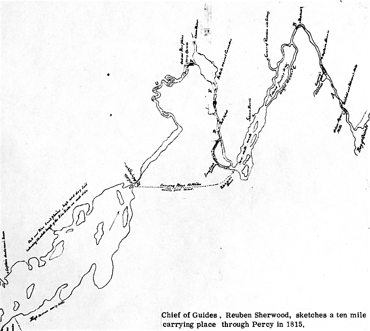
At the head of Nonwattonunk Lake we came to the ten-mile carrying place, there is good land for a road, and a few inhabitants already settled in the Township of Seymour, don't know what concession as this land is not surveyed, Oak and Pine Timber in great abundance. From examining my sketch with all the difficulty I encountered in passing the difficult rapids from Robinsons (24) to the foot of Rice Lake, I am of the opinion that the carrying place will be most Eligible...
In his commentary to this point, he echoes Collins' conclusions about the good land and difficult alternative river route. But now though, thirty years later, a few farmers greet him on the west bank of the river, probably at Percy Landing (Percy Boom). Rather than follow the portage, Sherwood prefers a northwesterly course to test the waterway, and he finds himself at Percy Creek having ascended nine feet over a one and a half mile rapid.
...Up this stream at this time loaded Batteau might pass two or three miles (I am told) by only clearing out the fallen timber...
He adds to this comment when he arrives at "H" (on his map close to present day Hastings)
...At H there will be required a dam and lock to make it navigable for loaded boats at low water, as the water was barely sufficient on the 24th May - at the head of this rapid (25), the carrying place leads off and to Robinsons, and I am inclined to think from my traverse that five miles in a direct line will fall in with Percy Creek when it can be made navigable...
In a letter accompanying his memoir, Sherwood tells Colonel Myers that he has "taken pains with the Indians" to find the sources of the different rivers passed by. It is possible that the Indians told Sherwood of the navigability of the Percy from either their own hunting experience or from ancestor's tales. Since the Percy flows far back into the township, Indians of an earlier century may have used it (when it was free of Lumbermen's debris) as part of a portage to avoid the falls and rapids.
Sherwood's plan of the route is clarified further in his letter of 22nd June, 1815 in which he creates a transportation highway with its centre in Percy.
...I have recommended the carrying place from Robinsons to Rice Lake, instead of the water round, and would advise that Boats should be built at Rice Lake to ply upon the waters to Coninanticocok (Balsam) only, and that the Boats from the Kingston and Conappanee Rivers should only go up to Robinsons. In carrying on this navigation you must be aware that Lands are yet un-purchased from Robinsons upwards. I am of opinion that if the township of Seymour was thrown open for actual settlers, it would fill up on the waters this year, by People of the Country or discharged soldiers but if purchases should be made from the Indians, Streets can be formed upon the plan of Yonge Street, at every carrying place...(26)
Sherwood envisioned one major portage that must be dealt with on the Trent Waterway. This was the "Percy". The 'Chemong" would be straightened to make it a five mile stretch and the "Talbot" (Ouskebawkning - green leaf place where we leave the river) could be avoided by damming and clearing the Talbot River for a canal. But the ten miles through Seymour and Percy were unavoidable, and because of the great length, a scheme had to be devised to make the traverse seem less awesome.
The Sherwood proposal suggested that a good road be built on top of the Indian path, over which men and supplies could be moved with rapidity and ease. Boats of all sizes were to be maintained in quantity and good repair at each end of the portage, so that their weight and bulk would not have to be grappled with with every crossing. Supply stations might be located at either end stocked by the farmers whom Sherwood hoped to attract to the "streets". In this way passage back and forth between Lake Simcoe and Kingston had to be broken at Percy.
Edward Smith's (27) 1816-17 map is further evidence of the design of this plan. Lieutenant Smith, 70th Regiment, was working with Lt. George Darley Cranfield, 90th Light Infantry Kingston, and Captain W.F.W. Owen R.N. on the whole communication that both Collins and Sherwood had previously been investigating. The final composite of their work, known as the "Owen Map", (28) differed from the earlier studies in the expertise with which it was drawn and the precise compilation of data.
Smith's main concern was the "Percy Portage", (a name first used by him I believe). His path's total length reached fifteen miles, six furlongs and one hundred yards; a good five miles further than any previous determination. On the map, the trail, marked in great detail, leaves the river some way west of "Little Bobakaijuen", later known as Crook's Rapids, and today Hastings. It pushes six or seven miles south and then curves gradually to the east for the same mileage to Percy Landing.
The trail passed over the present sites of Dartford and Warkworth. Only a few wise farmers were on these sites. The most northerly settled farmer who is plotted was McNutt, situated on Concession five, lot thirteen. Above his property the trail is called "Indian Path" along which there is no habitation. Below and as far as Percy Landing, the old path has been repaired and is referred to as a "road". Beside this road, ten or eleven farmers have cleared some land. Even a potash manufacturing building existed. (29)
Accompanying the map are some extremely interesting remarks made by Lt. Smith. They outline the townships riches; its fertile land, fine fish and creeks, lumber and mill sites. The detailed analysis that is given of the creeks might have been part of the surveyor's imaginative scheme to build inland canals to Warkworth or Dartford and thus shorten the long trip. It is more probable though that Smith was examining the land to see if its wealth could support hungry troops who would be travelling to the Upper Country.
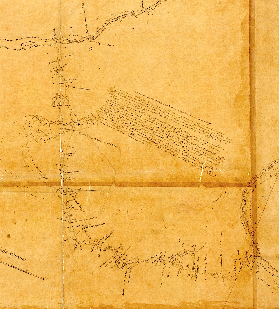
Section of the "Gold Mine Map" prepared by Edward Smith in 1816-17. The
upper portion of the Percy Portage leaves the Trent River at White Stone
Island (McGuires) just to the west of Little Bobakaijuen (Hastings).
This portion of the trail was followed overland by the Trent student
researchers in 1973. Lame and O'Meila Lakes were used as markers as were
the few topographical descriptions that are found on this map. ("Steep
hill", "stoney and uneven", etc.)
More details from the map can be seen
on the Story of the Percy Portage linked to this page.
The map is located at the Archives of Ontario.
Title: No. 2, water communication
between the Bay of Quinte & Lake Huron
Reference Code: RG 1 Unprocessed
Creator Code: R-Q~O18-27~SR 7111
Date: 1816
Barcode: B164200
No. 2 Water Communication Between the Bay of Quinte and Lake Huron. Remarks on the Percy Portage surveyed by Lieut. Smith (10th or 70) Reg. Between Robinsons and the Rice Lake in ascending the River Trent are two Falls and nearly a continuous Rapid, to avoid these and at the same time to cut off a considerable angle in the River is the object of this portage. The Road, which as far as McNutts is extremely good, lies in the Township of Percy, the land everywhere very fertile, the principal farms are Mallarys and McNutts, the latter has considerable quantity of cattle and his land is under very excellent cultivation. Great advantage accrues to the Settlement from the vicinity of Percy and Mill Creeks by means of which an extensive lumber trade is carried on in the Spring of the Year, the former of these streams presents many admirable situations for Mills, none however have as yet been established. Percy Creek takes its rise from the Rice Lake and empties itself into the Trent, 2½ miles N. of Robinsons from its source to its confluence. With Mill Creek it is much obstructed with old fallen timber and is very shallow and rapid having an average breadth of 25 feet, as far as this point Canoes ascend in the fall of the Year for the purpose of fishing. The Creek abounding at that season with peculiarly fine Trout and Salmon. (30) From this point the breadth and depth of the stream gradually increases, but it continues rapid until within 1½ miles of the mouth when it becomes smooth current with a breadth of about 50 and depth of 5 feet. The general breadth of Mill Creek is about 20 feet depth 1½, the stream very winding and rapid obstructed much with old logs of trees. There is no settlement beyond McNutts. The total length of the portage by measurement is 15 miles, 6 furlongs, 100 yards.
But this fifteen mile Percy Portage is certainly not the same portage that is marked on any of the earlier maps. In 1790, 1813, and 1815 the trail was almost straight, and measured eight miles seventy-six chains, and ten miles. It is not likely that early explorers straightened out such an obvious angle or misjudged the mileage by almost half. The largest Owen Map in the National Archives in Ottawa solves the problem. There, a quarter inch long ink line begins from the head of the "Little Bobakaijuen" directed slightly toward the southeast. Smith's Percy Portage is just to the west of this marker, which reads "Reported Path to Percy Landing about nine statute miles".
What actually happened to that shorter route can only be surmised. When the officials and Surveyor-General read Sherwood's report they were probably very impressed with his division of boat transport at Percy. His Yonge Street settlement plan also would have pleased them. But when Smith arrived in Percy a year later to make a road, he could see settlement stretching from east to west over the first four concessions next to an already worn road, and not along the ancient nine mile portage. Instead of trying to "grow" habitation along the old trail, he decided to follow the present pattern, which ran quite far west before it turned north up to McNutt's farm. Above McNutt's, an Indian Path reaching towards the Trent could conveniently be transformed into a wider road. Along this road the pattern of settlement would scatter farmers who would be encouraged to settle there by the government as the years passed. This then was to be the "downtown Yonge Street" of the Trent Valley, a place where bustling activity would never cease. The proposed "Chemong" and "Talbot" sections would come later and would become almost suburbs.
Today it is apparent that there is no Yonge Street in Percy. Somewhere in the decades following Reuben Sherwood's vision, new theories and interests emerged which made the portage obsolete.
Soon after Smith's and Owen's surveys, pleas and rough plans to the government were advocating that canals be built from the Rice Lake to the Bay of Quinte. In 1820 J.W. Bannister proposed that a Government Lottery should pay for this work. He later hoped that unemployed labourers from Great Britain and Ireland would construct the canal. (31 )
Once the inhabitants had a taste of this kind of thinking, the "old fashioned" portage was doomed. A portage was an adequate mode of transportation for a trade or military route but it could never satisfy the many incoming settlers whose increasing prosperity made fertile their imaginations. They wanted a canal! (32)
The advantages likely to accrue for them from the fulfillment of such a dream were best articulated in November 1833 by N.H. Baird, a civil engineer studying the waterways.
...To the country immediately bordering on the river, the advantages are too apparent, from the harassing inconvenience experienced in dragging every species of commodity and provisions required for the many wants of new settlements through, perhaps the worst roads in the Province, and obviate the many heart rending scenes of endurance, scarcely to be credited by an eye witness, ...The facility for the transport of Lumber from the waters above, and from the different manufacturing establishments now existing, and which must soon double, will form a very prominent feature in the advantages likely to follow ...To Government, the benefit must come more immediately home, in the increase in value of the many thousands of acres on, and contiguous to its (Trent River) banks. ...To this add the still more incalculable benefit this Province would derive from the Marmora iron works being set in operation... ...When the Trent shall be rendered navigable, the Settler and Merchant may have their goods shipped under their own eye at Montreal wharf, pass along the Lachine, Ottawa River, and Canals at Carrillion, Chute Aux Blondeau and Grenville, along the Rideau canal, up the Bay of Quinte, along the Trent navigation, Rice Lake to Peterboro' without ever once being disturbed after leaving the Montreal wharf, to say nothing of the diminution in freight, which must as a matter of course follow, and on the other hand it requires no stretch of the imagination to anticipate all those settlements in a few years contributing materially towards the export Trade and that Wheat, Pot Ash, Staves, etc. must be re-shipped as return Cargoes... (33)
Baird's conclusions convinced the officials of future years of the need for canals. The impressive rationalizations which today results in the destruction of this land were eroding it then also.
The Trent River was to be made navigable. The particularly tortuous stretch from Percy Boom up past Campbellford to Hastings would no longer cause any trouble. Not only had the Percy Portage bypassed this section, but six other paths had done so as well. (34) They were either short one mile lifts around the falls, or less hurried longer winter and hunting trails.
The Indians land paths, which had everywhere un-mazed the thick forests of the Lower Trent region, could never have destroyed the beauty that was. As the Sagetewedgewam ("river hard to travel") lost its meaning, so too the river lost its peaceful portages.
On the banks of the Otonabee
Trent University, August 1973
Michael Levenston
Also see the Story of the Percy Portage
End Notes:
NAC - National Archives of Canada - Ottawa
A0 - Archives of Ontario - Toronto
M&S Ministry of Natural Resources - Maps and Surveys - Whitney Block, Toronto [Now at Ontario Archives]
1. NAC - V1/409
A Plan of the District of Nassau in the Province of Quebec.
"For the service of his Majesty's Governor and Council Compiled in the Surveyor General's Office Pursuant to an Order in Council of the 22nd day of Feb. 1790"
Samuel Holland - John Collins
Scale two miles to an inch
Surveys used to compose map
- The N. Coast of L. Ontario by Lewis Kotte and James Peachy in 1784.
- Niagara River to the Falls by Lieut. Tinling, 1785.
- Communications from Toronto to Lake la Clie by John Collins, 1785.
- Toronto Township by Alexander Aitkin, l788.
- The South Coast of Lake Ontario from Niagara Eastward and the rest of the plan Southward and Westward from the Falls, are taken from Sketches.
The Collins map reprinted here is from Guillet P.41.
2. The Trent Region had originally been surveyed by John Collins in 1785.
"Deputy Surveyor-General John Collins was actively engaged in the earliest surveys of Ontario. He operated at Kingston in 1783, and westward of it in the townships of Ernesttown, Fredericksburg, Adolphustown and Marysburgh, in the following year. He accompanied Sir John Johnson in 1784 with the party of U.E. Loyalists under Captain Michael Grass and assisted in their settlement administering the oath of allegiance to them under a Special Commission. But he had been connected with Canadian surveys long previously, having received an appointment from Major Holland as early as the 8th Sept, 1764 as Deputy Surveyor-General. Sharp differences of opinion occasionally arose between Major Holland and Mr. Collins, as, for instance in the laying out and settlement of Kingston, and in those disputes he seems to have had influence enough with the Governor-General to enable him to prevail, probably by the backing of Sir John Johnson. Outside of his professional life very little has come down to us about him. He was an ardent Freemason and in 1787 founded St. James Lodge in the King's Rangers at Cataraqui."
- From 1905 Ontario Bureau of Archives Report P. CXXIX
3. Hamilton to Lord Sidney - March 10, 1785
MG 11 Q24, Pp 242-243, NAC
4. "Benjamin Frobisher (l742?-1787) was born in Yorkshire, England about l742. He emigrated to Canada, and embarked in the fur trade as early as l764 in partnership with John Welles, and he was later associated in turn with James McGill, Richard Dobie, and his brothers Joseph and Thomas. So far as I can discover, he never went west of Grand Portage but looked after the Montreal end of the business of Frobisher and Co. in which his brothers were partners with him. He died at Montreal on April 14, 1787."
From Document Relating to Northwest Company. By W. Stewart Wallace M.A. Champlain Society, 1934.
In 1795 Frobisher drew a map of the Ottawa, Trent, and Toronto routes to Lake Huron. None of these three different trade routes are drawn accurately at all. It is reproduced in Guillet, P.l33.
5. Frobishers to Haldimand - October 1784, Series Q V 24-2, Page 409, NAC
6. Hamilton to Lord Sidney - April 7, 1785, MG 11 Q24, Page 248, NAC
7. Benjamin Frobisher to Hamilton - May 2, 1785, C.O. 42, Vol. 47, Page 132, Guillet, NAC
8 Hamilton to Collins - May 22, 1785, Report of the Archives of Ontario, Page 372
9. Hamilton to Collins - May 28, 1785, Report of the Archives of Ontario Page 373
10. Benjamin Frobisher to Hamilton - Dec. 15, 1785. RG4 A1 - NAC - Volume 29
11. John Collins was instructed to explore the Trent on May 22 and 28, l785. I have not been able to find an account by Collins of his early trip. In the National Archives, two reference cards prove that he did make the Journey.
10th Oct. 1785 John Collins, Expenses of expedition to Lake Huron
22nd Nov. 1785 John Collins
Pay list of persons employed on the survey on the route of communication from Cataraqui to Lake Huron.
I was never able to find these documents even after an hour's search with an archivist who was working on the papers.
A letter of May 5th, 1792, from Quebec from Collins details a journey made by the surveyor up part of the Trent in the year 1791, July 27 through 29. Since it is a very early picture of the river, I have included it in the appendix.
12. From Collins' notes on the 1790 District of Nassau Map (Healey's Falls) "This fall is twelve feet high, the hill you ascend at landing is on a level with the top or the Fall, the Carrying Place across is twenty-five chains in length, the road is good and you embark on a level with the Water. -"
(Middle Falls) 'This Fall six feet high, the Hill at landing is twelve Feet, the Carrying Place across the Point, is twenty Chains and the road is level and good to where you embark-"
(Ranney's Falls) "A Beautiful Fall of fifteen feet high, the bank at Landing is three feet, the Carrying place on the opposite side is agreeable to the dotted line being forty chains in length, and a good level road to where you embark, you then descend a Hill of twenty feet -" The dotted line spoken of just above can be seen if one looks carefully at the Collins map that has no notes upon it in the Archives of Ontario.
13. Note on 1790 District of Nassau Map
14. From Chewitt's 1792 Diary from June 22 to July 5
Field Notes
Vol. 1 pp. 176-178
M&S
This complete Journal is informative and quite entertaining. It is also another version of the waterway to Percy Beach and describes a portage that would have been lost otherwise. This portage connected the Bay of Quinta to the Salt Spring. Chewitt sketches this path and the river on a colourful map at M&S. Mr. McDonell who accompanied Chewitt has also written an article on the Salt Spring, which is more of a scientific analysis of the water itself. M&S.
15. "A Map of the Province of Upper Canada describing all the new settlements, townships etc. with the Countries Adjacent, from Quebec to Lake Huron."
Compiled for Major General John Simcoe by David William Smyth Esq. - Surveyor-General. Published by W. Faden, April 12th, 1800.
16. M&S - Hambly, Patents N34 1795
- Gree1y, Field Notes #286 1796
17. Land and State Book of Upper Canada
June 17, 1797 NAC
18. Land and State Book of Upper Canada
June 17, 1797, NAC
This 1799 list by Jones is the very first unofficial census of Percy Township. The remarks give the historian rare clues to the true settler history. Turner, Silver and Woodworth, for example, who are not registered on the 1803 census, are noted by Jones as having either returned to the States or not settled.
- 1803 First census found (A.O.)
Annual Return of the Inhabitants of the Twp. of Percy
Benjamin Richardson (servant)
Burnabas Brunson
Thomas Gastin
James Merriam
Rufus Wells
John Dingman
Giles Stone
Gutar Dingman
Resolved Cleaveland
Richard Sharp
Thomas Curtis
Jeremiah Wood (servant)
John Grover
Osimus Brunson
Aron Holt
Roger Merrils
Jacob Dingman
Amasa Brunson
Susanah Merriam
Joseph Jones
Frances Warner
Charles Trip
Abraham Cronkite
22 men, 22 females, 9 males above 16, 25 males under 16,
2 females above 16, 27 females under 18, 2 servants,
(Conflicting report of 45 males under 16. Total=127.
Page 29 Guillet, Annual Return)
19. Land and State Book of Upper Canada
July 1799, NAC
20. A Map of the Located Districts in the Province of Upper Canada from the latest surveys in the Surveyor-General's office by William Chewitt, Senior Surveyor and Draughtsman Under the direction of Francis Gore esq. Lieutenant Governor, by William Faden, Jan.1, 1813. A.0.
21. "Sir W.F.W. Omen was born in 1774, entered the Navy as Midshipman in 1788, serving in the ships Vengeance, Hannibal and Cullodon. In 1808 he was taken prisoner by the French and detained at Mauritius for two years. He was employed in the survey of the Bay of Fundy and Nova Scotia and promoted to Rear Admiral in 1847, obtaining the rank of Vice Admiral in 1854. He died at St. John, New Brunswick, in November 1857, aged 83 years. Admiral Owen acquired property on Campobello Island, Passamaquoddy Bay, New Brunswick from which he was known as "Campobello" Owen."
From Simcoe County Pioneer and Historical Society
Pioneer Papers No. 5, Barrie 1912
He also worked on the Great Lakes for his brother between 1815 and 1817. The Admiralty then sent him into African waters and other places for almost twenty years.
22. Transaction of the Colonial Office Records
- Naval establishments
- Survey of the Lakes
1816 Lower Canada No. 141.
23. His father was Loyalist Thomas Sherwood, first settler in United Counties of Leeds and Grenville in June 1784. Reuben (1775-1851) conducted township surveys as early as 1799. From 1809-1820 he made government surveys dividing townships: Marmara, Nelson, Pittsburgh, Sherbrooke, Augusta, Bastard, Bathurst. Lansdonne, Leeds, Nassagauega, Yonge. Richard Birdsall served under him at one time.
-Reuben Sherwood's complete memoir is printed in the Appendix
MG11 Q142, Pt. 1, pages 3-14
NAC
24. From the Field Book of Seymour Township, William Browne, 1819.
Seymour was first surveyed by William Browne in 1819 (M&S). In Browne's field book a sketch of the west side of the Trent shows Percy Landing in the Gore below Concession one. Also in that Gore above the landing and just underneath lot five of concession one is Robinson's house. Robinson's was well known as the jump off point for the Percy Portage.
In Richard Birdsall's 1821 sketch of a small block of land laying in front of a part of the Township of Seymour commonly called the 'Gore' there are three buildings shown in the Gore. (Township Papers Seymour, Con. 1, A.O.)
No 'Robinson' could be found in the abstracts of deeds for the years 1790 to 1830 in any of the surrounding townships. Nonetheless a splendid letter was "excavated" from the mounds of township papers at the Ontario Archives. The letter is addressed to the famous Peter Robinson in Toronto.
Seymore 30th May 1831
Sir.
I have understood that the Township of Seymour is to be sold by a late owner of the executive government of this Province, I think it highly necessary for me to state to you for your information, that I have made application to the Honorable Col. Wells. while this Township was in the hands of the Board of Education to purchase lot number 5 of the first concession on which lot I have resided for the last twenty two years and have made considerable improvements, - a good Frame House, Barn, a log house, and about thirty acres cleared and under fence, (?) these particulars. They go to show the situation I am in with regard to preference to purchase as I am convinced the Government will do me Justice, and I am at the same time I ask to make application to purchase from you sir and am willing to pay a fair Estimate value for it.
I also was a sufferer with Burgoyne and have resided in Canada ever since. I beg you will favour me with an answer at your earliest convenience.
I have the honor to be your most obedient servant
William Robison
The squatter leaves out a 'n' in his signature. Lot 5 Concession 1 Seymour is just above the Gore but Robison may have believed that he was there technically. His testimony puts him among the oldest settlers arriving in 1809.
25. The exact position of the 'lead off' for this carrying place has not been determined yet. N.H. Baird's report of 1833 in his initial survey of the Trent River section of the Canal (P. 151, Guillet) roughly measures this rapid from whose head the portage begins. The foot of these rapids is 'immediately below Asphodel bridge, six miles from Rice Lake; at this point the 5th and last general section occurs, in extent about one/half mile and rising 7 feet 9 inches which overcome brings the navigation into the head or summit pond of Rice Lake.'
26. See complete letter in Appendix
27. Lt. Smith's first name established by the Canadian Forces Directorate of History (Edward).
28. Different Owen maps exist in both Toronto and Ottawa. They are usually broken into sections which vary in number depending on whether a real or photostat copy is available.
In Toronto:
The Smith survey or the Percy Portage is possibly the original (Gold Mine Map). Its black ink on parchment-like paper is aesthetically very pleasing. (M&S) The different draughts men modified the amount of detail reproduced on each of the larger copies.
A clear copy in 8 sections (A.0.) with note:
Measured Sketch of the Water communication between the Bay of Quinte and Lake Huron, by the Rice Lake etc. etc. From the Lower Falls of the River Trent, to its Month by Lt. Cranrfield DAQMG - The remainder by Capt. W.F.W. Owen R.N. and Lt. Smith 70th Regt. in the years 1816 and 1817 - Copied from the original surveys by Lt. G.D. Cranfield 90th Regt. Inft.
Quebec 6th May 1816 (probably 1818 )
Remarks:
The hight (sic) of the Ground in Feet is expressed Roman Initials - The Breadth of the River in yards by figures. The soundings are in figures.
Scale 1000 yd. to 1 inch
In Ottawa: NAG
V11/417 1817 10 sheets, extraordinary detail
V11/410 1818 5 sheets, a giant with fine colouring
V1/M10 1818 1 sheet
There are also three copies of a rather slick composite of Owen's Map done on one page. (1851, 61, 79) Part of one is included in this printing. If one of these colourful maps were reprinted commercially, it would be received joyfully by thousands of inhabitants and touring boaters in the Trent Valley.
29. There is a great deal of mystery and historical significance in the faceless names that dot the banks of the Trent on Smith's map. The houses placed on the north shore of the river sit on Indian land before treaty and Crown Ownership. Not until 1816 was the land (Asphodel township) ceded to the government and surveyed by Richard Birdsall. The only mention anywhere in history of Captain McDonald's, Morrison's, and Dingman's uninhabited houses on the north shore, is on this 1816 map.
Kent and Wallace's land on the Otonabee River are probably the first farms in the Otonabee area.
Captain Charles Anderson at the foot of the Otonabee was the owner and operator of the Indian trading post. Anderson had taken over the trading post from an Indian named Herkimer.
Above White Stone Island (McGuires or Conclin), lived Mr. Turnbull whose story has survived. When Robert C. Humphries made his way to Asphodel in the summer of 1819 from Pennsylvania, he came up through Percy Township. At the Trent he is said to have crossed the river on a ferry that was operated by a man who helped Birdsall survey Asphodel.
At this point, at the top of Smith's Percy Portage, the first bridge built across the Trent was constructed in 1824. In 1823 a committee studying the wisdom of building such a bridge, reported back to Parliament.
To the Honorable the Commons House of Assembly in Provincial Parliament assembled. December 24, 1823.
The Committee to whom was referred the Petition of the Inhabitants of Otonabee and Asphodel, in the Newcastle District, beg leave to Report,
That a bridge across the River Trent at the lower end of the Rice Lake, the point at which the Petitioners contemplate its erection, is absolutely necessary not only to obviate the difficulties complained of in the Petition, but also for the encouragement of others; who in the event of the attainment of this object will be induced to settle in rear of those waters, the only objection to which, your Committee are assured, is the length of time every year that the inhabitants in that part of the country are deprived of all communication with the old Settlements and Lake Ontario, such communication being an object of the last importance to emigrants thrown upon their own resources in a new country. Taking this view of the subject, and taking also into consideration the great exertions which the present few Settlers will have to make in accomplishing an object which, although of public and future advantage, the Petitioners are nevertheless from their peculiar circumstances compelled to undertake alone, your Committee would not feel justified did they not recommend the prayer of the Petitioners to the most favorable consideration of your House.
Henry Ruttan, Chairman
Page 580, Report of Ontario Archives, 1914
The Smith Portage which lead to this bridge was obviously the most important road in Percy. The first Percy road book (1825-49, a rare document, is hidden in the Archives of Ontario. (Court Records No. 7 General Quarter Sessions Newcastle District Road Reports Vol. 107.) Every stretch of road that was built or repaired is listed and described in this book. The first four items are missing and items 40-50 also. However enough information is left to trace the movement of settlement branching off the Percy Portage. Item ten is dated 1828, "from between lots 19 and 20 Concession 3 to the old road -- to have a road laid out and opened from the old road and to have the old road shut up, etc." The old road is most likely Smith's portage. The farmers along the portage can all be traced in the Abstracts to the land deeds for Percy or in the Township Papers in the Archives of Ontario: McNutt, Dingland, Allan Brown, William Townshend, Leggitt, Marriam, Malary, Robinson, Masters, etc.
The dotted line marking Percy and Mill creeks is the 'supposed' course of those creeks.
The canoe route is drawn on Rice Lake. This was probably the route most frequently used by the Indians.
Many Indian paths are also indicated. (See endnote 34.)
30. Salmon still made their way up the Trent in the early part of the 19th century. Early fishermen would speculate on whether or not these fish visited the ocean every year. They usually concluded that the fish must have, since no salmon was ever seen in any river or lake above the Falls at Niagara. In 1817 the inhabitants of Sidney and Rawdon wrote an angry petition to the Commons House of Assembly of the Province of Upper Canada.
This Memorial respectfully showeth,
That we, the inhabitants of the Township of Sidney, subscribers hereto, beg leave to represent to Your Honorable House the great inconvenience and loss that we in common with all the settlers on the River Trent sustain in consequence of the practices of some unprincipled characters, who, taking advantage of the existing laws regulating the catching of salmon in the District of Newcastle, the lines of which District crossing the River Trent at some distance above its mouth, leaves them at full liberty to pursue their depredations by making weirs and dams across the river under the pretence of catching eels and whitefish, and do almost totally obstruct the passes of the salmon up the same, and when the waters of the river are very low (as was the case last season) few or none escape; and thereby cut off a very material source of supply to the back settlers. Your Memorialists greatly fear that the salmon meeting with such difficulties in ascending the river, will abandon the same, and take some other course. They therefore pray that Your Honorable House will be pleased to take this subject into Your Consideration, and extend the provisions of the salmon laws in the Township of Sidney.
Your Memorialists, as in duty bound will ever pray.
Sidney, 12th March, 1817.
signed A1ex'r McDonell and others
Ontario Archives Report, 1912, p. 403
Salmon fishing in the Percy probably ended when the sawmills became too numerous. The profusion of sawdust on the water and the multitudes of oak staves annually floated down the creeks and rivers annoyed the fish.
see Authentic Letters from Upper Canada, Thomas Radcliff, 1954, for an account of salmon fishing as it probably was on the Percy.
31. Guillet, pp. 145-146
32. The Percy Portage was not completely lost after Smith's and Owen's work in 1816-17.
On the James Chewitt map of 1826 the portage is drawn as a road copied from the Owen map. (A.O.)
In 1836 Chewitt's Percy Portage is copied on the James Wyld map. (A.0.)
Before Edwin Guillet's Valley of the Trent was published (1957) the author corresponded with Mrs. Helen Marryat of Hastings. They discussed the history of the Lower Trent and Mrs. Marryat sent Mr. Guillet much new information. Some of their correspondence is preserved in the Trent University Archives in the 'Marryat Papers'.
In a letter (Feb. 28. 1955 or 56), Mr. Guillet, referring to the Percy Portage which he sees on the Collins 1790 map says, "I did not know before I studied this map that there was a portage." From that date on the two historians attempted, without too much success, to discover where the trail had been. On March 5, 1957, Mr. Guillet closed off incoming material for his book but remarks to Mrs. Marryat, 'The only thing, therefore, that we could now use is any trace you can locate of the eight-mile portage from Percy Landing ..." A very rough map of the trail that Mrs. Marryat drew is in her papers at Trent.
The only other persons who actively searched for clues to the whereabouts of the old trail, before Mr. Cumming and the "Percy Portage People", were Mr. Everett Elmhurst (a local Historian), and Mr. Fred Richardson (an archaeologist).
33. Guillet, pp. 158-160
34. Three portages existed around the individual falls on the stretch above Percy Boom.
1. Trent Upper Falls - Healey Falls - included at that time 25 feet in cascades and a rapid to Crow's Forks - the 7 or 8 foot fall was called Mawlaughwong by the Indians - portage on east side of river 2730 yards to Crow's Forks. (Owen Map)
2. Middle Falls - a succession of falls between the islands 16 feet - portage 1500 yards to Point Flora - rapid to the head of the portage. (Owen Map)
3. Lower or Big Falls - Ranney's Falls - 1st fall 15 feet, 2nd fall 3 feet - portage 40 chains. (Owen and Collins Maps)
Two long portages bypassed the falls altogether.
A. From the top of Beaver Island (now Nappan) on the west side of the river, across country to Percy Boom - read "Indian Path from Robinsons." (Owen Hap)
B. From the top of the Middle Falls on the east side of the river, southward to Lot 14, Con. 1, Seymour approximately – read "Indian Path from Sol. Harris 7 miles." (Owen Map)
There is also a short portage on the north shore of the Trent just east of Wilson Island. (Owen Map)
Appendix 1
Champlain and the Percy Portage
Champlain accompanied an Indian war party through the Trent Valley in 1615; a documented voyage that has been of great service to both historical reconstruction and regional tourism. The tourist industry, who have no pretences, believe that Champlain stopped everywhere. The self-assured historians also know the real route but each scholar 'knows' a different one.
The late Leslie Frost's Forgotten Pathways of the Trent (see bibliography) has forced me to join this circle of madmen who jeer at historical truth. In his provocative and original new book, Frost argues that Champlain and several hundred Indians would rather have used the Ganaraska portage from Rice Lake to Port Hope on Lake Ontario, than follow the too turbulent River Trent down through the Bay of Quinte. The author uses a much needed 'common sense' interpretation of the voyage rather than the scholar's strict translation of Champlain's original memoir.
“If the traveler crossed the AB (Percy Portage] portage to Percy Landing (4 miles south of the now Campbellford), the distance from thence to Lake Ontario is 26.21 miles. In that distance the river descends 145 feet. This presently includes eight locks on the Trent Canal. Before any canal was constructed there was one rapids known as Nine Mile Rapids, and in 1867, despite the fact that there was some canalization in the lower river, 8 miles was still unnavigable (54). What then would be the choice of the traveler? Obviously if he were going to take the river route, he would take the AB portage for the reasons given. This would be nearly 9 miles by land. He would then be faced with over 26 miles of very turbulent river with the unnavigable Nine Mile Rapids. At a minimum, his portages from Percy Landing to Lake Ontario by the river route would total at least 9 miles. Thus in going by the river route from Rice Lake to Lake Ontario he would be faced with over 20 miles of portaging and carrying, including the AB portage and as well facing all of the dangers of the balance of the river. The question therefore is, would he take the river route or would he take the Rice Lake or Ganaraske Carrying Place of 11 miles and then paddle along the protected north shore of Lake Ontario to the Carrying Place portage (where the Murray Canal is now located, a mile or so in length, leading to the Bay of Quinte? His choice would be obvious. He, of course, would take the Rice Lake Portage."
The few obtuse sentences, which Champlain wrote about his journey, seem to contradict this theory. After the explorer and his Indian companions had crossed the Talbot portage and had entered Balsam Lake, Champlain says.
"From here issues a river which makes its discharge into the great lake of the Onondagas (Lake Ontario). Having crossed this lake (Balsam) we followed the course of the said river, downstream continually, some sixty-four leagues, to what is the entrance of the said lake of the Onondagas, and on our way we portaged round five rapids, some four to five leagues in length. We also passed through several lakes of very considerable size as is likewise the said river which passes through them, and which abounds greatly in good fish."
Champlain followed the river 'continually' to the confluence at the 'entrance' of Lake Ontario. This would be Adolphus Reach Upper Gap at the east end of the Bay of Quinte. He thought that the Bay was a part of the river and lake system through which he was travelling. (This accounts for his sixty-four-league measurement.)
His 1632 map shows the Trent waterway and verifies the above interpretation of his voyage. On the map the river is very fat with many lakes and enters Lake Ontario at the upper east end where the St. Lawrence meets the Trent. If Champlain had portaged to Port Hope, he would have realized that Port Hope was not near the 'entrance' to Lake Ontario.
Mr. Frost's theory infers that the war party was in a hurry and would therefore take the shortest and easiest route. However Champlain tells us that he hunted bear and fished with his comrades all the way down the river.
"We went by short stages as far as the lake of the Onondagas hunting continually, as is mentioned above, and when we reached it we crossed it at one end, that pointing eastward which is the entrance to the great river St. Lawrence."
The Trent Valley was a famous hunting ground for Indians from all the surrounding areas. The Indians wished to make a surprise attack on their enemies. Iroquois scouts could spot a large number of war canoes paddling along the north shore of Lake Ontario easily. The snake-like Trent would shelter and hide the many warriors.
Collins remarks that the Indians used the Ganaraska carrying place in the spring when the water was very high (see appendix). Champlain's expedition was travelling in the middle of September. In that season the water on the lower Trent had calmed somewhat and more of the river would be navigable.
Although Champlain's measurements are often inaccurate, he says that he portaged five times, 'some' of these portages 4 or 5 leagues in length. The short Fenelon Falls portage was obligatory. At least two other short portages would be necessary on the lower Trent. His 'some' very long portages were probably the 'Chemong' and the 'Percy'. Champlain would have walked across the straight 9-mile portage in Percy. And then again he might have taken the longer 15-mile route for hunting and fishing close to the Percy Creek.
Appendix 2
Memoirs of the Route from the Bay of Quinte up the waters of the Trent to Lake Simcoe.
Reference to Sketch
A
I have put the letter A as a mark of reference on the sketch for the whole of the rapid from the mouth of the Trent to Capt. Gilbert Harris's, being a distance of 9 miles: but Harris living on the east side of the stream on Lot No. 6 in the 6th Concession Township of Sidney. The course from the mouth or the River to Harris's is due north with a good Wagon Road on the East side: the whole fall in this distance may be computed at about 120 feet: Loaded Boats have frequently been poled up this rapid after the 20th of June on the decrease of the Water; but at high Water they cannot come up without the help of towing Paths and some Capstans fitted at the sharpest Points. At one mile up this stream stand Adam Myers Mills at the foot of the rapid on the SW side. At two Miles up on the East side stand Fairfield and Ripsoms Mills, belonging to John Cummins Esquire of Kingston, in one of those Mills is a gang of an 24 saws.
On the rapid above Cummings Mills to Captain Harris's, there is a smooth rock bottom and at low Water I am of opinion it will be necessary to confine the stream to one channel, otherwise it may be too shallow for loaded Boats to pass. Every convenience of Timber and Store to carry on any Works at this place are to be found along the banks in abundance.
B
From Captain Harris's proceed North of the Stream against a smooth current 4-Miles to Rosebushes farm, where the River bends southwest high Oak Hills appearing on each side, Just above Rosebushes is a rapid of about one quarter of a mile in length in which I took the fall to average about 7 feet. We poled up our Canoe and a loaded Batteaux might have gone at that time. At low Water it would perhaps be necessary to assist the depth of Water on one side.
C
From the Rapids at B we proceed about 1 Mile S.W. to the foot of the long Island, this Island is about 7 miles in length, and the general course may be about W.S.W. The south channel is largest and deepest therefore will be the best to form a Batteaux Channel in: will require one dam and one Lock.
D
The dam to be about 80 Yards long and eight feet high. The NW Channel is where the canoes pass upwards and loaded boats might have gone up at the time I passed without difficulty. The Land on both sides through this Country appears to be excellent a little of, from the Stream. From the Island our course is S.W. seven Miles through to Non-watto-nunk Lake, being one half a Mile to a Mile in width. The Township of Seymour on my right said to be most excellent Land. At the head of Non-watto-nunk Lake we came to the 10 Mile carrying place there is good land for a road, and a few inhabitants already settled in the Township of Seymour, don't know what concession as this Land is not yet surveyed. Oak and pine Timber in great abundance. From examining my sketch with all the difficulty I encountered in passing the difficult rapids from Robinsons to the foot of Rice Lake I am of opinion that the carrying place will be most Eligible.
From Robinsons our course is N.W. about 1 and one/half Mile to Percy Creek; the Rapid in this distance falling about 9 feet. Up this stream at this time loaded Batteaux might pass two or three Miles (I am told) by only clearing out the fallen Timber. From the Creek our course is N.E. for 1 one/half Mile more to the head of the Island. The whole fall from here to Robinsons is 20 feet. From hence we carried the Canoe about two miles till we pass the fall at D, which is a perpendicular of about 15 feet more down to the head of the Island. The Bottom of this river is all a flat Rock. and the Banks are good generally falling off towards the Waters Edge with a flat, and a very little clearing away of the timber from the banks would form a path.
The last mile the banks become steep the water running very swift and to appearance 3 or 4 feet deep, and will be a difficult part to make navigable. The fall at D may be easily canalled on the West side where Nature has pointed out the place.
E
From these falls the general course is NNE about 4 Miles all the way up strong rapids to the falls at E where we came to Crows Lake. These falls and rapids altogether down to D may be counted at 55 feet.
The falls are in several cascades of 4, 5 and 6 feet each, will require great expense and Labour to make it navigable.
Up Crows Lake, our course is north about 2 Miles where the rice lake branch comes in from the west. The crow branch seems to be a large stream.
F
At F we carry about 1 and one/half Mile on the north side of the stream, on oak and Pine plain, at about one Mile up N.W. is a perpendicular fall of ten feet, and at the head, what is called the high falls being about 25 feet, and the intervening rapids may be counted as 20 feet more is a difficult rapid to render navigable. The falls at each situation can be easily locked. The soil high and dry is excellent for roads or settlements.
G
From this we have travelled every course between N.W. South and SE passing up some small Channels and several Islands against smart currents for ten or 12 Miles, forming a bow: on the whole the base of which may be SSW about 6 Miles; then came to still Water one/half a Mile broad, and about six Miles in length to a “Bob, a, ca, qu, en" or rapid of 1 Mile in length and falling about 6 feet at H.
H
At H there will be required a dam and lock to make it navigable for loaded boats at low water, as the water was barely sufficient on the 24th May - at the head of this rapid, the carrying place leads off and to Robinsons, and I am inclined to think from my traverse that 5 Miles in a direct line will fall in with Percy Creek when it can be made navigable.
From H we pass up Rice Lake SW about 16 or 17 Miles to the mouth of the River again.
I
I have sketched the most conspicuous Islands as I went along. The breadth of this Lake varies much from the deep Bays on each side; the general width is from three to five miles. This Lake abounds with masquinouge and Black Bass. The Land on all sides this water appearing high and sandy. Oak and Pine the principle Timber, some Norway pines. The first Six Miles from the rice Lake up the stream is a smooth current our course due north to the little Plains - than SW 4 Miles - then from West to North crooked say seven miles more where we found a dry Point to Encamp upon, having passed a great proportion of drowned land, although the land appeared good a little distance off. Then 2 Miles NNE where the stream opens broad and we turned West is the six Mile carrying place, one mile - For the last 3 or 4 Miles the lands became better along the bank of the river.
J
At the carrying place marked J is the foot of the rapids on the river flowing from Chabaticqinaung Lake, and the distance to go round by water is about 50 Miles, and, altogether about 10 or 12 Miles of rapids, all of which is saved by a short carrying place of six Miles and a half chained by myself and Capt. Anderson and even this might be shortened perhaps a Mile by forming one direct line.
This distance commences and ends with a small plain of about three-quarters of a mile on each end - and the rest of the land excellent for Farms.
K
It appears to me that I rose near 60 feet when at K, or Chabotiquiang Lake, higher than the rice Lake.
From the carrying place NE about six Miles, and then turned up the West branch of those abundant channels, running between Towpenkou Islands, say one Mile north - then two miles west when we came to a great opening; then W. 3 Miles to the little Plains Where W. Mcan was killed: then West 3 miles to another great opening where we turned North about 6 Miles to the little Babacaqnen or rapid, and about 2 Miles more to the larger stream, both of which came from Sturgeon Lake, the first stream is the one used for canoes to pass up and down; but the larger or Northern stream is that which the fur traders formerly used to run their boats up and down.
L
At L the rapid may possibly make re-decent of 7 or 8 feet in the distance of half a Mile - it will require two dams, and locks to secure an easy boat navigation. The distance to Sturgeon Lake is about 3 Miles West.
Sturgeon Lake lies SW exactly and is about 15 Miles in length and 2 in breadth, has only two small Islands, on which the Indians were planting Corn apparently good land on both sides. I am told a large stream comes in at the south end thereof. We go up this Lake about 10 Miles, when we turn round Sturgeon Point, then north up the Bay about 3 Miles to the stream - Then West up the stream two Miles more to where the stream narrows, and we meet with high steep rock banks to the high falls marked M.
M
These falls are a perpendicular pitch of 17 feet and there may be a fall of 3 feet more in the distance of 300 paces up to Camerons Lake. The fur traders used to take boats past this place on rollers of wood without the help of horses or oxen for the small distance of 50 yards. There can be no difficulty in locking these falls as the stream is very deep at the foot thereof. The water on the smooth rock for about 10 Chains above the fall is from one foot to 18 Inches in depth the 1st of June 1815 and might be confined to form one deep channel to the head of the falls.
Here we came to Camerons Lake (where Elliot died) - This Lake lies about NW, 3 and one half Miles to the stream proceeding from Cominaticocok Lake; found the Land excellent round Cameron Lake, and this as well as the other Lakes abounds with bass and Masquinonge of the best flavor.
N
We follow the stream nearly West about 2 and one/half Miles up and very crooked passing the rapid at N - in the first one/half Mile it is a stoney bottom, about 2 to 3 Chains in breadth for the last half Mile, a rapid with loose stones on the bottom, and at this time about one to two feet water, loaded boats might now pole up, but the stream will require clearing out, as it shallows, and perhaps a dam and lock may be necessary; As we enter Cominaticocok or Balsam Lake, it appears in front; say due west about 5 miles to the carrying Place at Q.
Q
The Lake lies to the North 6 or 7 Miles, we pass round the south end of a large Island, in front of us, and a deep west Bay to get to what is called the 17 Mile carrying place: - The stream coming into the North end of this Lake I am told is rapid and extends a great way to the North.
P
From Q on the west shore of Cominaticocok Lake, to carry W to N about 2 and one half Mile to a small stream but deep, called Talbot river at P this stream bears Northerly; Its source as the Indians informed me being a Lake lying at the South end, and between Sturgeon and Cominaticocok Lakes. W- have the Land track to Lake Simcoe on our left at 1 and one half Mile from Cominaticocok. The Land is generally good on this carrying Place and stoney - And it appears to me that the Talbot river is much higher than Cominaticocok.
The first appearance of this creek it is about 50 links broad, in an Alder Marsh and the trees and small bushes intercept the passage very much for the first four miles, and the general course may be West. From thence the general course of the stream is SW until it falls into Lake Simcoe and there are three rapids the whole distance, being about 20 Miles by Water. These rapids can be easily dammed up except the upper one, where the banks are low, and, in the last six miles of the River there is vast Quantities of fallen Timber that must be cleared out to make the navigation complete. I enter Lake Simcoe at the NE Bay the course to the river severn about NW and perhaps 30 Miles distant 12 Mile Point appearing due west about 12 or 15 Miles, and the Kings stores on Holland River distant about 30 Miles SW where I took Yonge Street out to the Town of York 36 Miles.
(Signed) B. Sherwood
Captain of Guides to Kingston
22nd June, 1815
Sir:
Herewith I enclose a sketch and memoir of the route from the Bay of Quinte to Lake Simcoe by the way of the Rice Lakes.
I have taken pains with the Indians to get every further information of the source of the different Rivers which I passed, in case of any future period it should be thought necessary further to explore the Country behind us - and their connection with the Ottawa forms many cross routes.
I have recommended the carrying place from Robinsons to Rice Lake, instead of the Water round, and would advise that Boats should be built at Rice Lake to ply upon the waters to Cominaticocok only, and that the Boats from the Kingston and conappanee Rivers should only go up to Robinsons. In carrying on this navigation you must be aware that the Lands are yet unpurchased from Robinsons upwards I am of opinion that if the Township of Seymour was thrown open for actual settlers, it would fill up on the Waters this year, by People of the Country or discharged Soldiers but if Purchases should be made from the Indians, Streets can be formed upon the plan of Yonge Street, at every carrying place.
My sketch and observations have been all read over at the Surveyor-Generals Office, York, and I was happy to find that my work came out within five miles of the truth in the whole distance. The Surveyor-General gave me every facility in his power towards elucidating and correcting my sketches, and expressed his willingness at all times when a professional person should be sent on similar occasions.
He gave me the Copy of Crown reserves for Eastern and Johnstown districts, on account of filling in Settlers below, the whole inclosed to Sir George Murray, Lt. General, as he is gone. I hope you will stop one Copy.
I have te te te
(Signed) R. Sherwood, Captn. of Guides
To Colonel Myers D7 2nd M Gen. to te te
B-138 CO 42 Canada Vol 172, 173 1816-1817
Appendix 3
Proceeding on my Route from Kingston to Lake Huron
Wed. 27th July set out at 6 o'clock from Capt. Singletons on the River Saganskkohon the wind N.W. and blew hard, the Canoes heavy loaded were in great danger of sinking, at 11 arrived at the mouth of the river of Saggattawegewan, named the Trent. This river forms an excellent Harbour for vessels, the water being upwards of 12 feet deep, dined and set out at one o'clock passed the first rapids, killed some red salmon, the land high on the north, level on the south, the River is about 40 Perch broad, At 4 o'clock sunk one of our Canoes - encamped at 6, about six miles 63/4 from the mouth of the river, the land Good. on the north the whole distance, the water sufficient for Batteaux. Thurs 28th set out at 6 o'clock; at 10 arrived at the Head of the Rapids, good water over these rapids for Batteaux, the River from 60 to 80 perch broad, excellent land on both sides, dines at one o'clock. set out at two, here the River makes a great turn to the South, passed several large Islands, and encamped at 6:30.
Friday 29 July set out at 5:00, the land good on both sides, passed several Islands, at 8 breakfasted on a small island at the Head of the still water, found a family of Missasaga Indians on the Island, who showed us the salt they had made a day or two before, from a very great salt spring at the foot of a high hill on the south side opposite the Island, and observed that three kettles of that water, produced 1 kettle of salt and that the Indians in that part of the country all made their salt at that Spring, the salt appears to be good and well-tasted.
Saggattawegewan signifies a River of strong waters - which the Indians never attempt at this season, but make use of the portage marked N.0. which brings them into the Rice Lake, 11 miles, 10 chains of a Carrying Place from L. Ont.
Quebec 5th May 1792 Signed John Collins
Appendix 4
Important Indian Names in the Trent Valley
Trent River - Saggattawegewan or Otonibee
Talbot River - Nummaibene Seebe or Sucker
Scugog River - Yawbashkaokawk
Severn River - Matchedash
Long river between Balsam & Cameron Lakes - Wesaweutay Seebe
Lake Simcoe - Shaineong
Balsam Lake - Balsam Copeiba Lake or Canenandacokauk
Sturgeon Lake - Nummey Saukyagun
Pigeon Lake - Shebaughtickwyong West Lake
Chemong Lake - Shebaughtickwyong East Lake
Rice Lake (probably Stony and Clear Lakes) - Caughwawkuonykauk
Rice Lake - Pemedashcoutayong
Trent Lake (Percy Reach) - Nonwattonunk
Part of the Talbot Portage - Oushkiebwa Kawning
Each time an Indian name was marked on an old map the spelling of the word was altered.
Selected Bibliography
Bigger H.P. The Works of Samuel de Champlain Vol. 1 1615-1618 Toronto, Champlain Society, 1929
Canada; Public Archives, Ottawa
-Map library
-Various documents
-Important ones listed in endnotes
Frost, Leslie; Forgotten Pathways of the Trent
-*Mr. B.D. Sandwell, the president of Burns and MacEachern Limited, has allowed the "Percy Portage People" to peruse the galley sheets of this book. We are all very grateful for his help. Frost's book won't be published until Oct 1973.
Guillet, Edwin Clarence; The Valley of the Trent
Toronto, Champlain Society, 1957
Helen Marryat Papers, Trent University Archives
Ontario; Dept. of Public Records and Archives, Toronto
-Map Library
-Crown Land Papers
-Township Papers
-District, county, and Municipal Papers
Ontario; Ministry of Natural Resources. Maps and Surveys, Whitney Block, Toronto
Oral history; numerous people in Asphodel, Percy, and Seymour townships
Thomson, Don.W.; Men and Mridians: The History of Surveying and Mapping in Canada, Volume 1, Ottawa, Roger Duhamel, Queen's Printer, 1966
Revised April 11, 2016