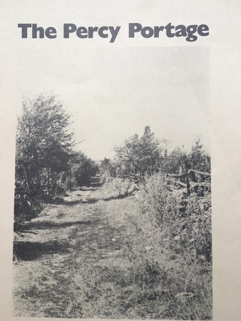
The Story of the Percy Portage
By Ferne Crystal, Gordon Holyer, Beverly Hood, Robin Hood, Michael
Levenston and Borge Lind-Petersen
Trent University Press 1973
(This is an excerpt from the 180-page report.)
Also see the History of the Percy Portage
The Story of The Percy Portage chapter was written by Robin Hood and Ferne Crystal.
For several years an older resident of Havelock, Mr. Jim Cumming, has been intrigued with portage routes on the Trent waterway and especially with an unexplored, and seemingly lost portage in Percy Township. He transferred much of his enthusiasm to a member of our group, Robin June Hood who, with Mr. Cumming's incentive, tried to delve into this unknown path.
The only original clue was found on a map done by John Collins in 1790. A straight line marked the route, which crossed three streams, from the east end of Rice Lake to Percy Landing. Robin's curiosity led her to visit Mr. Featherstone, who is employed by the Trent Canal System. He agreed that this portage was most probably one of the foremost carrying places on the Trent Waterway. The group was formed and we began to seek support from various conservation authorities and historical societies in the vicinity such as Otonabee and Lower Trent Conservation Authorities, the Peterborough Historical Society and the Peterborough Naturalists. The first step was to locate the exact route, which we later planned to reconstruct.
Although this route was changed various times before we discovered 'proof' of the Indigenous portage, the original idea was incredibly accurate. On a snowy February day, Robin and Gordon went exploring down bumpy concession roads, attempting an initial try at analyzing the geography. It is slightly difficult to think while sitting comfortably in an automatic vehicle, but the bush work was to come later. Also, the Indians are no longer the primary occupants of the area, so the question of six amateur historians trampling through the property of private landowners aroused some thought. The Beldan Atlas assisted our search for landowners but only the ones who existed in 1878. To find more recent information Robin and Ferne journeyed to the registry office in Colborne where we were charged two dollars to locate names of property owners. The assessment office helped us to find the addresses, but we did not contact the people immediately as the route was only tentative and our project's grant had not yet been accepted.
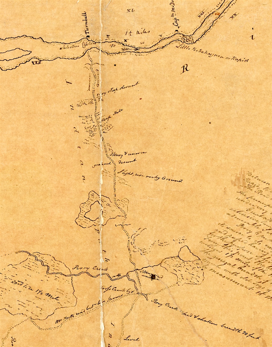
Detail(1) 'Gold Mine Map' showing Percy Portage at Archives of Ontario. 1816. Title: No. 2, water communication between the Bay of Quinte & Lake Huron.
Before approaching the specific landowners, we needed support from the council of the area. Gordon and Ferns made a few trips to Hastings, where the response was unexpectedly positive. The reeve, Carl Heath, a councilwoman, Pat Stewart, and Sam Kilpatrick, head of the Chamber of Commerce, converted our skepticism into enthusiasm. We also paid a visit to Mrs. Frank Brown who supplied us with some interesting history on the Alderville Indians who live in the area.
All the local people we spoke to, continually mentioned the name of Mrs. Helen Marryat, whose knowledge of the history of the area superseded any others. Unfortunately, she had died about eight years previously, but her collection of papers was thankfully stored in the Rare Documents section at Trent University. Michael became totally engrossed in the twenty-two volumes of her work, and, page-by-page, he searched for information concerning our portage, concentrating mainly on Mrs. Marryat's correspondence with Edwin Guillet, author of Valley of the Trent. Finally, Michael found a map on which Mrs. Marryat had marked her theory of the portage. In the meantime, we had been researching Champlain's early journals, Baird's (an early surveyor) reports, and secondary readings in geography, archeology and early settlement history. All of these sources, including the gossip and fish tales Mrs. Marryat revealed, gave us a taste of the life and time with which we were dealing. The Indians of the area at the time of white settlement (early 1800's) supplied the earliest Europeans with a storehouse of knowledge for everyday living. The early roads were also, at one time, Indian paths and before that, deer paths. After two weeks of intensive research, we were convinced of the importance of the trail as one of the main carrying routes on the Trent system and we decided to name it. We compromised by naming our project, The Percy Portage, which is obviously of "white" European origin and using an Indian symbol, meaning person, for the sign to be placed along the trail.
A bone of contention still loomed above us. We had various theories on the portage routes, but all of the maps we had found to date were vague or drastically out of proportion and inaccurately drawn. Then, Michael uncovered our main clue, the "Goldmine Map" by Lieutenant Smith which showed a portage in Percy Township. It was done in great detail with particular landmarks noted on it.
The secretaries for the Department of Lands and Forests were amazed at the ecstatic enthusiasm which erupted when Michael, after long hours of patient work, discovered this un-catalogued map. This map was undated but we later discovered that the whole Trent System was mapped in 1816 by a Captain W.F. Owen who appeared to have been commissioned to study the Trent as a feasible transportation route. This find led Michael deeper and deeper into archival research while the rest of the group began to roam the countryside in search of the ancestors of names mentioned on the "Gold-mine" map. Elderly residents remembered much and enjoyed relaying the details to a new and interested ear.
Other problems began to appear once the central research period was over. The major concern at this time was a means of transportation. Various local people had to be contacted and preliminary bush work done on the possible route. Hitchhiking was not so simple on old, scarcely used concession roads. Without a vehicle we were at a standstill, which was extremely frustrating since there was much to be done.
As well as the necessity of a car to assist us in visiting landowners and local historians, we needed to inform them of our existence and our purpose. We were not interested in a nature, hiking trail, but we desired to mark the portage for the historical purpose of saving it from obscurity. We were not aggressive when approaching those people and used the newspaper as our preliminary media. The Hastings Star, Campballford Herald, Warkworth Journal, and Peterborough Examiner introduced us in a favourable way, which proved helpful when meeting people along the route. A school principal in Warkworth reprinted our letter in the town newspaper, which we accidentally discovered two weeks later.
Now it was time to move into the immediate area. But first an agreement had to be made on which route was to be marked. Guillet's book, Valley of the Trent, showed Collin's 1790 map of the portage as a straight line and Chewitt's map of 1826 showed it as a roughly sketched curved line. Smith's map of 1816 showed it curving also, but with much greater detail. Another idea was that the Indians carried their canoes across land three miles and then travelled Percy Creek until it met the Trent River at present day Meyersburg. We concluded that both the overland route and the water route would be utilized at different times of the year for purposes of warfare and later fur trading. We made an arbitrary decision to mark the creek route for aesthetic and scenic reasons, as well as being well travelled. The third reason was purely practical; by following the creek we hoped to avoid interrupting farmers' fields and houses. As well, the overland route had become the first roads, many of which are now well travelled.
We were extremely lucky in choosing Hastings as our home base. Since we had no vehicle, Council-woman Pat Stewart moved our equipment, and the group, to a campsite, which Earl Heath allowed us to use free of charge. Later we were able to rent the old Hastings train station where we set up an office-living type arrangement. After being settled for only a few days, people began appearing who were interested and full of advice. Small Ontario towns have an abundance of open minded, friendly people. In Cliff Skinkle's barber shop one could also be stimulated by an entertaining as well as informative conversation. Many were able to suggest specific sites of Indian artifacts, as well as the "specialists" on various topics. All our leads veered towards a prominent farmer of Asphodel Township, Everett Elmhurst. Mr. Elmhurst was very impressed with Michael's research of early settler history and especially with his discovery of Birdsall, one or the first surveyors, the great grand-father of E. Elmhurst. As a result of Michael's continual research in the archives, he turned up many obscure maps and land deeds which were particularly relevant to our work. By this point our mass publicity drive was beginning to pay off. He received a letter from Mr. Hoyt Thompson, an old friend of Mrs. Marryat, who had seen one of our articles in the Hastings Star and remembered an occasion where Mrs. Marryat had pointed out to him the location of an old Indian portage in the area. Our visit with him proved fruitful as Mr. Dick Williamson joined us and we discovered that on his old property there was a cold spring running into the Trent River which was very popular with the local people. We also learned from our readings that many portages begin at a cold spring and the one we were looking for likely began there. Mr. Williamson assured us that we would have no trouble passing through the land of the present landowners. This was an exciting moment as we began to see our academic bookwork becoming more practical. Very often research and old documents can place you in an ideal world, where you lose contact with concrete reality. The fieldwork was clearly in sight with the fact that the land topography, roads and streams began to correspond to the empirical evidence which Michael had discovered in the Ontario Archives.
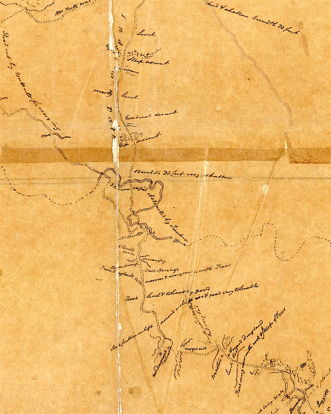
Detail(2) 'Gold Mine Map' showing Percy Portage at Archives of Ontario. 1816. Title: No. 2, water communication between the Bay of Quinte & Lake Huron.
As well as Michael's archival work, we searched for information in the Hastings and Warkworth libraries. The librarians were exceptionally helpful and interested, providing the names of people they thought would be helpful. Our knowledge of the history of Percy Township and Indian portages was growing, so it became necessary to correlate our information. Extensive notes had been taken, but a summary, largely for our benefit, was needed. The Department of Natural Resources in Napanee had required from us a monthly report on our progress and so a lengthy letter was sent which impressed them very much and assisted us in pulling together many of the important details.
Alternate portage routes were continually being suggested to us. Mr. Elmhurst told us of a suspected ancient Indian ceremonial ground located at the east end of Rice Lake, just above Scriver's Island, on the highest piece of land in the vicinity. On the top of this hill there was a natural level clearing. A trench or trail seemingly ran along the side of the clearing and there was an apparent circle of rocks pounded into the ground. An interesting fact about these rocks was that they were weatherworn, which meant they had to be carried up a steep ascent, leading to the idea that the area had some ceremonial significance. Elmhurst introduced us to another valuable resource person, Fred Richardson, an anthropologist who is fascinated by Indians of the area. These two men took Ferne down Rice Lake, pointing out various archeological sites along the way and explaining their significance, ending the trip at the ceremonial campground now referred to as Mike Fitzpatrick's hill. Later that day Everett Elmhurst showed us his artifact collection which was found in the area and convinced us more positively of the Indian occupation in Percy Township.
The time for bush work and the marking of the trail was nearing, but we needed the signs. With helpful hints from Tony Welbourne of the Otonabee Region Conservation Authority, we obtained galvanized metal sheets which were cut into 5' squares and painted florescent orange and blue.
But there were still a few things to be done. We visited some of the historic sites in the area; Century Village in Lang, the Peterborough Petroglyphs (which are rock carvings done by early Indian tribes) and Serpent Hounds, a famous Indian burial ground first recorded by David Boyle in 1896. We visited Mrs. Frank Coveney who, as a centennial project, started to collect various farm histories in the area. Her notes were helpful in tracing old houses and discovering how the farmland traded hands. The municipal office in Warkworth helped us find names of property owners along the first stretch of road. But as the creek meanders, not following any straight roads, the clerk could be of little assistance to the creek landowners at that early date.
By this point transportation had become so crucial that in order to visit these people, we finally had to resort to renting an arrogant orange Vega which took us from place to place for one week, after which time we returned it. One reason was that the price of renting it turned out to be a rather great capitalist rip-off. A fortunate coincidence arose in that we inherited a decrepit old white Station Wagon. Unfortunately, the Station Wagon ate one quart of oil daily, but with good care and pampering, it was reliable down twisting, bumpy gravel roads. Now we were able to contact the owners in order to obtain their permission to traipse over their land and place a few five-inch florescent signs on trees along the way. We wrote a general letter, introducing ourselves and explaining our purpose. We stressed that it was primarily a historical trail and no tourists would flock over their land, scare their cows or litter pop cans along their cornfields. The reactions varied as the people varied. Some people were totally indifferent, others were curious as to why. A few people were excited though, and asked to be kept up to date on our progress. Their excitement rejuvenated our enthusiasm. Only the "odd" person was skeptical or leery, but they agreed in the end.
Although we had visited most of the farmhouses along the route, we were not sure if we had approached all the landowners, as many people rent property. This led us back to the registry office in Colborne. Here we obtained a lengthy list of owners, many of whom lived in the Toronto area, with the majority of others living in the immediate vicinity. This meant that a trip to Toronto would have to be made to those cottagers who lived in Percy only in the summer, and also to contact the real estate offices, for they owned much of the creek land. We mentioned to the real estate agents that the idea of an Indian trail going through one's property would be a good conversation piece. In Colborne, Michael also attempted to look for information concerning old maps and land deeds, but as the registrar was not present at the time, he was unable to do so. This built up much frustration with the bureaucracy since he knew that behind those locked doors, there existed much pertinent information. This frustration died as he realized the endless amount there was to learn so he consented to the idea that he must set limits somewhere. He soon met Marjorie Scriver, a friend of historian Mrs. Marryat.
Since we were now positive of the landowners, Bev and Gordon went visiting the majority of people and came back full of tales and experiences which were informative as well as humourous. One man informed us that the creek, which in the summer is almost totally walkable, becomes so high that fences are wiped away in the spring. Another fellow told us of a neighbour who owned a "basketful of arrowheads" which he found on his property. Some farmers had came upon artifacts by accident while ploughing their fields which led one to believe that a great number of Indians camped and travelled in this area. Many people on the route liked to mention that Champlain was said to have travelled down through this area in 1615, but how accurate this is, is still in question. Champlain's journals are too vague to make any final decisions. We approached many hard working farmers whose only fears were of us trampling their fields or frightening their cattle. One farmer informed us that there would be no use placing a sign on a stake in the middle of his field for it would just be plowed down. Hugh Jenney, a newcomer to the area at Maiden's Mill, told us of a story Miss Maiden passed down to him. He said that thirty-five to forty years ago, a point on the creek was once an Indian village. Many "I remember when" stories were slightly farfetched and it wasn't too difficult to separate the salmon stories from those with some validity.
All of the individual landowners gave us permission. The only other group to approach was the Township Council in connection with placing our signs in Percy Township Park. The meeting was informal yet all those present attempted to make it as official as possible. We were granted permission with only one stipulation. The signs were to be placed at least six feet off the ground to be out of reach to the cattle - a purely practical reason. Since we now had verbal permission to cross the land, we began walking, discussing the different routes that could have been used. Would they keep to high, well-drained land or would they follow depressions and swamps, offering more protection from the weather? A number of questions were raised and with the help of various resource persons, the conclusion was drawn that routes had a tendency to follow the sides of ridges and level areas.
In our search for people with some background in Indian history, we were recommended to see Nigel Drayton at Gore's Landing. A few of us went and were moved by this white-haired artist, related to the Rubidge family, whose understanding of the Indian ways and culture was deep-rooted. His artifact collection can be described as no less than phenomenal. We visited him again and that time he let us read part of his written material and photograph his Indian artifacts. One or his arrowheads was nine inches long and perfectly symmetrical, which makes one realize what precise experts these early craftsmen were.
Another group of people who were of great assistance to us were the Ganaraska Trail group, who were clearing and extending a nature path. Their project, like ours, was funded by the Federal Government. In the fields of geography, tree identification, cartography, etc., our knowledge was extremely limited. We had a good collection of maps, including topographical, concession maps and detailed aerial photographs. By an in depth study of these, we prepared ourselves for the terrain we would encounter. The Ganaraska group walked the first portion of our trail with us, remarking on the land structure. They later showed us the procedure for making line maps and a detailed map of the route. It was a relaxed easy setting in the Hastings train station that evening and it we pleasant for both groups to be able to relate to others doing work of a similar nature.
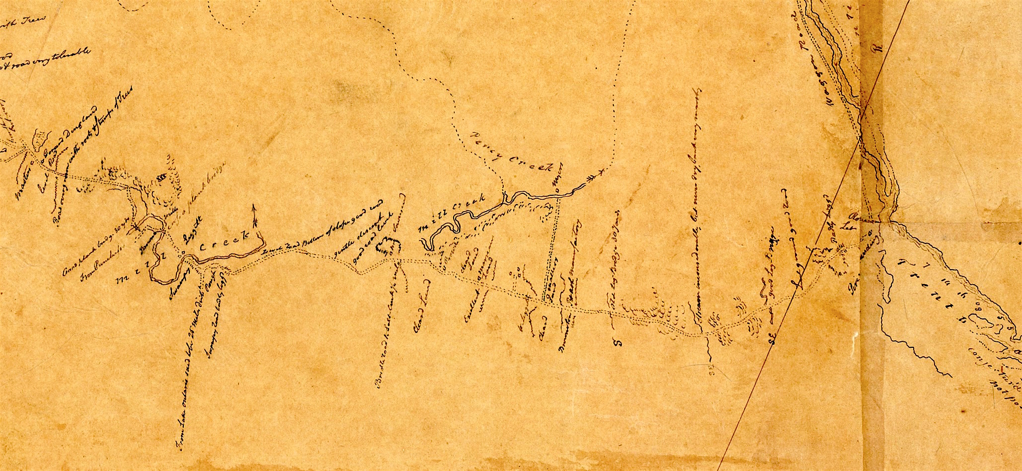
Detail(3) 'Gold Mine Map' showing Percy Portage at Archives of Ontario. 1816. Title: No. 2, water communication between the Bay of Quinte & Lake Huron.
By the middle of July we needed a more expert opinion on the archeological portion of our project. Archeologists J. Melbye from University of Toronto and Matt Hill from Waterloo University paid as a visit. We asked Fred Richardson to join us and he had much to offer in that his knowledge of the area is great and he showed us the place where excavation took place not far from the trail.
While part of the group was making detailed observations, discovering who and what existed along the present day route, more archival research was being done in Ottawa. We walked much of Percy Creek checking the feasibility of canoe travel. Although some portions of the creek didn't cover our ankles, there were other areas so deep that five foot Beverly was forced to swim, work boots and all. It must be noted that the water level is lower in August than any other time of year and the Trent Canal System could easily have altered the flow of water in the creek. One farmer, Bill Petty, remembers his father speaking of taking a boat down the creek which indeed suggests that it would have been deeper. These innocent bushwalkers were mercilessly exposed to stinging nettles despite their vain attempts to avoid these unpleasant members of the plant kingdom. The stream was abundant with fish and we saw numerous carp and mud suckers swim by our feet as we waded through both the heavily silted and rocky areas of the creek. There were frogs of all shapes and sizes and also painted turtles. We spotted two owls and many ruffled grouse which startled us, their colours camouflaging them in the wooded areas.
After a few days of bush and creek walking - legs covered in scratches and bites from unknown insects, Michael returned from Ottawa, full of life with some new finds, only to discover five exhausted crew members. But it did not take long to realize the importance of his finds - Reuben Sherwood's (an early guide) memoirs. They were written in 1815 while he was doing a detailed study of the Trent Waterway System. He confirmed our "creek" theory for he mentioned the possible navigability of the creek.
Luck seemed to follow as one day Morley Dunk, owner of Dartford Pond, told us that he would be draining the pond which would give us the opportunity to see the creek in its natural state. The pond was man-made by the building of the dam. Morley's reason for draining it was that a beaver had crawled in and eaten away part of the wood, causing a leak. With the drainage of the dam, the water flow became much stronger downstream, and below Highway 25, there was white water. The banks had flooded and our smallest crewmember, Bev, had to grab onto an overhanging tree to avoid being swept away by the strong, hidden undercurrent. Back at Dartford, great excitement arose when the pond was drained. Suckers, rock bass, sunfish and shiners were being scooped into nets by the dozens by children and adults alike. There were also numerous frogs, snakes, crayfish and snails. Clamshells made patterns along the sand where the water had receded. We saw one snapping turtle, and later Morley told us he saw an eel swim by. The draining was well worth seeing and if it ever occurs again, we would advise you to go. This was a lucky year as the only other dam along Percy Creek, at Maiden's Hill was also drained. It is interesting to note that the original creek ran through different parts of the pond at Dartford and Maiden's Hill.
Now, it was finally time to mark the trail and the six of us decided that it must be a group effort. A shovel, an axe, a few hammers, nails and our florescent orange signs were the only equipment necessary. We began at the cold spring where we all refreshed ourselves with the delicious spring water. With the help of Borge's strong arm, we chopped a few poles on which we put signs up in treeless areas. As we hiked, a few of us took photographs, some carefully studied the map and marked our exact location while others put up the signs. We met various fields of mild cattle along the trail, most of whom viewed us skeptically. They seemed to avoid us as much as we did them. The deer flies and mosquitoes weren't so leery of us and approached freely. Aside from the scorching sun, everything was relaxing and went smoothly. Feona and Lyn Brownlee joined us, resounded their facts on the area and enjoyed the attention they received as they rode on the backs of Gordon and Borge through the nodding thistles. Everyone was affable and a cold drink made the hot weather bearable.
We decided to mark the creek at strategic places only. We thought it not exceedingly picturesque to see florescent orange markers on trees when paddling or walking the scenic creek route. The signs are appropriate along the land route, but when they are not a necessity, as along the creek, they could prove an eyesore. The marking of the trail accomplished the first part of our goal. Next we had to compile our information into a coherent report. At this point we received a long awaited copy of the galley reports for the late Leslie Frost's book on the Scugog area. In his book, he made reference to our portage providing some interesting historical points for Michael to muse over.
There seemed to be a wealth of material, enough for years of research. We divided our report into various sections, with each person in charge of one portion, yet everyone contributing constructive criticisms. In the field of archeology, we visited a Trent University professor, Richard Johnson. whose research specifically involved Rice Lake. He gave us access to all the sites in the area which had been excavated, allowing us to analyze the situation in relation to the Percy Portage. Plant and wildlife identification was another major section. For this, Bev went collecting all sorts of obscure wild flowers and weeds, and after much bookwork came up with the even more obscure names for these plants. History and early settlement in the portage area received intensive research with the majority of the information found in archival exploration. A detailed map of the portage noting the landforms was also made. Photography was done by a few group members with the appreciated assistance in the darkroom from John Przybytek.
Upon developing each of the aforementioned topics, information and techniques of printing methods in the various fields was begun. Upon development of photographs, negatives of the prints had to be obtained in order to be copied in the printing process. Maps involved strictly line work. A cover was designed and after accumulating all the material, the final editing took place. Printing began with the aid of Trent University.
So, after months of effort by the members of the Percy Portage crew, with a little help from our friends and about $7,800 from the federal government, the story of the Percy Portage has now begun to be told.
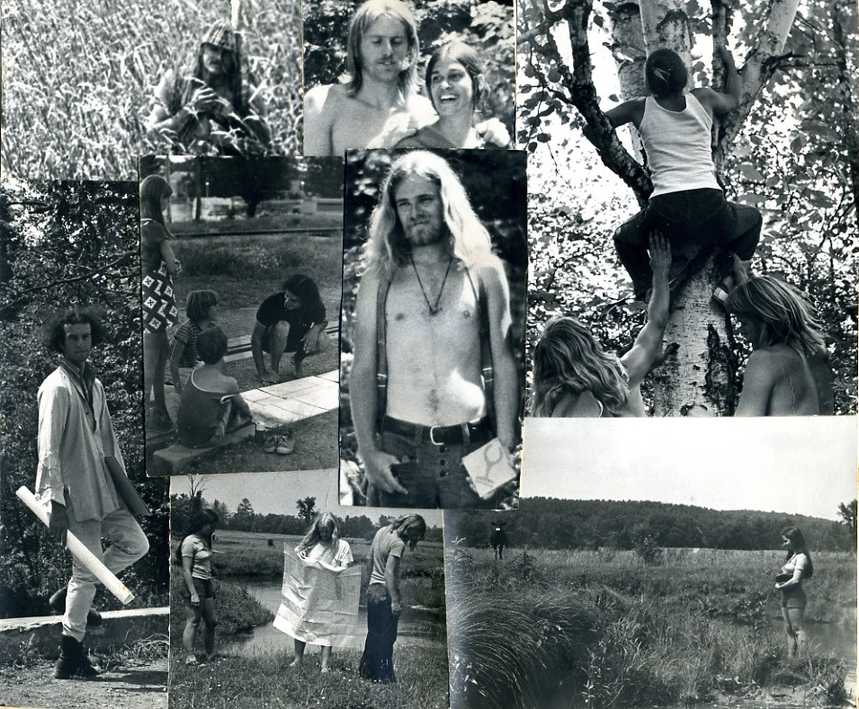
Trent students search for the Percy Portage in 1973.
Top centre: Borge Lind-Petersen and Ferne Cristall
Right top and bottom: Beverly Hood climbing tree and in field
Left holding map and crouching with children: Michael Levenston
Centre without shirt: Gordon Holyer
Bottom centre next to stream: Robin Hood
See an old video showing the students searching for the portage in 1973.
The Gold Mine Map can be found at the Archives of Ontario.
Title: No. 2, water communication between the Bay of Quinte & Lake Huron
Reference Code: RG 1 Unprocessed
Creator Code: R-Q~O18-27~SR 7111
Date: 1816
Barcode: B164200
Also see the History of the Percy Portage
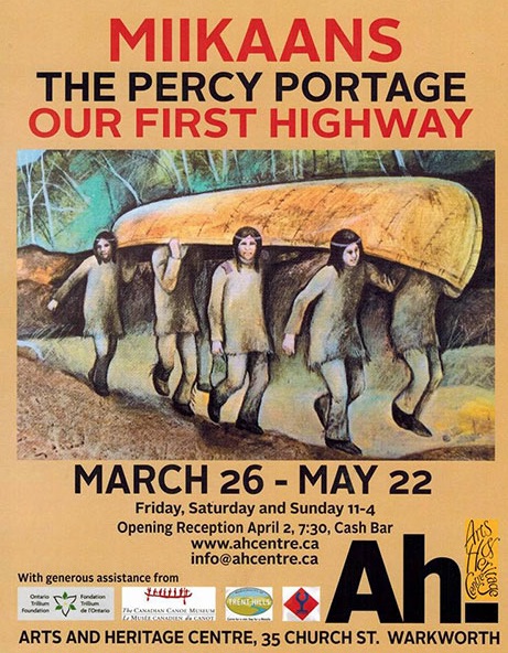
Percy Portage Exhibit in 2016
March 26 - May 22, 2016 Exhibit at the Arts and Heritage Centre of Warkworth, Ontario
See Video from 1973 showing Trent Students

 Video of the search for the Percy Portage


See Video 'Percy Portage - Champlain Route' from Museum Exhibit


 Video of the Percy Portage Museum Exhibit


Revised Jan. 12, 2020


  cityfarmer@gmail.com
See Video from 1973 showing Trent Students
Video of the search for the Percy Portage
See Video 'Percy Portage - Champlain Route' from Museum Exhibit
Video of the Percy Portage Museum Exhibit
Revised Jan. 12, 2020